Map Kibera: Learning from six years of digital citizen engagement
Ground Truth Initiative
“How have citizens of Kibera slum been able to influence local change using maps and other digital tools over the past seven years?”
December 2016 End date
September 2017
Issue
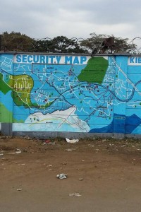
In 2009, Map Kibera began when 13 young people from the Nairobi slum created the first online, open map of their community using OpenStreetMap. The project uses community mapping and technology to engage citizens and present evidence to policy-makers on what is needed. Since then, Map Kibera itself has grown, and inspired many other similar projects. But how have citizens shaped change using Map Kibera, and how has government responded?
Project
The research is mapping the information networks that use Map Kibera’s data, and charting the influence of the data through the network. The researchers are interviewing local public officials to determine the impact of citizen actions using the data, and studying Map Kibera’s own outreach.
The study asks whether information has brought new awareness or understanding of the issues, and what actions have been taken based on this knowledge. It also aims to uncover barriers to understanding and action.
Related projects
Partner
Ground Truth Initiative is a new media and technology consulting company specialising in community-based participatory technologies, especially mapping and citizen journalism, in poor and marginalised regions of the world. They help bridge technology gaps by promoting the use of open data and collaborative platforms, designing projects, tools and websites to empower people to harness the potential of the internet to guide their own development processes.
Publications
-
 View publication
Open mapping from the ground up: learning…